Irvine, CA
Irvine (California) is a city in Orange County, California, the United States of America.
| irvine Irvine | |||
|---|---|---|---|
| honorary city | |||
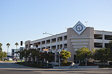
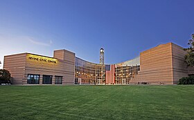  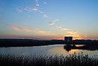 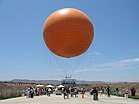 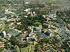 Clockwise from top: Irvine Civic Center, San Joaquin Wildlife Sanctuary, University of California Irvine, Orange County Great Park balloon, Irvine Spectrum. | |||
| |||
| Locations in California and Orange Counties | |||
| Coordinates: 33 degrees 40 minutes 10 seconds north latitude 117 degrees 49 minutes 23 seconds west longitude / 33.66944 degrees north latitude 117.82306 degrees west longitude / 33.66944; -117.82306 coordinates: 33 degrees 40 minutes 10 seconds north latitude 117 degrees 49 minutes 23 seconds west longitude / 33.66944 degrees north latitude 117.82306 degrees west longitude / 33.66944; -117.82306 | |||
| country | | ||
| State | | ||
| county | | ||
| corporatization | December 28, 1971 | ||
| naming | James Irvine | ||
| administration | |||
| - Type | city manager system | ||
| - City Council | Mayor of Donald P. Wagner Melissa Fox Jeffrey Laloway Lynn Scott Christina Sea | ||
| - City Manager | Scene Joyce | ||
| area | |||
| - Meter | 66.454sq mi (172.115km2) | ||
| - Land | 66.106sq mi (171.214km2) | ||
| - Water surface | 0.348sq mi (0.901km2) 0.52% | ||
| Elevation | 56ft (17m) | ||
| Population (2016) | |||
| - Meter | 258,386 | ||
| - Rank | 3rd in Orange County 16th in California 85th in the United States | ||
| - Density | 3,900/sq mi (1,500/km2) | ||
| family name | Arvanite | ||
| equal time | Pacific Time (UTC-8) | ||
| - Daylight Saving Time (DST) | PDT(UTC-7) | ||
| ZIP code | 92602-92604, 92606, 92612, 92614, 92616-92620, 92623, 92650, 92697 | ||
| area code | 949, 657/714 | ||
| FIPS code | 06-36770 | ||
| GNIS feature IDs | 1660804, 2410116 | ||
| sphere of influence | 74 miles | ||
| website | cityofirvine.org | ||


| Flowers | Agapanthus |
|---|---|
| Wood | camphor |
| insect | Red-billed partridge |
| vegetable | asparagus |
Overview
In 1971, it was established as a vast agricultural land. Today, the city is known for its rich higher education and low crime rate. It is located between Los Angeles and San Diego and is widely included in the Los Angeles metropolitan area. The population is 209,806 (in 2010), the area is 120.4 square kilometers, and the population density is 1,659.1 (in 2005) per square kilometer. The flowers of the city are Agapansas, the trees of the city are Camphor, and the insects of the city are Agaha. The climate is Mediterranean.
city planning

Irvine was a planning city developed mainly by Irvine (en) since the 1960s. In 1959, a plan to develop cities with a population of about 50,000 mainly at the University of California, Irvine, was formulated, and on December 28, 1971, a large-scale development plan that was larger than the original plan was approved by a referendum. The layout of Irvine was designed by the Los Angeles architect William Pereira. The name of the city is divided into residential areas called 'mura.' Each residential area is divided into six lanes, and each residential area has a shopping facility, religious facilities, and a residential area where schools are set up.
crime prevention
According to the FBI announcement (2005), Irvine is the safest city in the United States. The number of atrocious crimes per 100,000 residents is 30, the lowest in the United States. In the ranking of "Safe Cities in the United States" released by Morgan Quitnot, Inc., it was ranked in the top 15th place every year, starting with the 1995 edition.
regulation by residents
Since the planning stage, the city's landscape has been taken into consideration and it has many green areas, reservoirs and parks. In Irvine, strict restrictions are imposed to protect the scenery of the city. The association of housing owners in each residential area regulates the appearance of the house (color of the house, roof design, tree planting type, etc.). In harsh areas, even vehicles that can be parked outside the house are restricted.
population dynamics
According to a 2010 census, about 50% of the population are Caucasian, about 40% are Asian, about 7% are Latin American, about 1% are African and the rest are others. According to age, 23.5% were under 18 years old, 14.4% were between 18 and 24 years old, and they were constructed as educational cities. In the family structure, 53.8% are married households and 32.9% are single households. The education level of the residents is high, and 60% of the residents have graduated from university. The average household income is 85,624 dollars.
Economy
The Irvine Business Complex (IBC) area is the hub of high-tech companies, and is also called the "second Silicon Valley." UCI, Irvine Unified School District (the school district that manages public schools from kindergarten to high school), Verizon Wireless, and Broadcom are large employers.
In addition, many Asian-affiliated companies have their headquarters in Irvine.
Irvine-based company
local company
- In-N-Out Burger
- Western Digital
- gateway
- Taco Bell
- Paragon software
- VIZIO
- Broadcom
Other
local corporation of Japanese companies
- Asics
- Atlas
- Shimano
- Toushiba
- Mazda
- Marchan
- Malcolme
Other
Other
- NHN (Local corporation of Korean company)
- Kia Motors (local corporation of Korean companies)
- Samsung Electronics (a local corporation of Korean companies)
- BenQ (local corporation of Taiwanese company)
Other
climate
| Irvine climate | |||||||||||||
|---|---|---|---|---|---|---|---|---|---|---|---|---|---|
| Month | Jan | Feb | March | April | May | June | July | August | September | Oct | November | Dec | Years |
| Maximum Temperature Record °C (°F) | 36 (96) | 35 (95) | 37 (98) | 40 (104) | 41 (105) | 43 (109) | 43 (110) | 39 (103) | 43 (110) | 41 (106) | 38 (101) | 35 (95) | 43 (110) |
| Mean maximum temperature°C (°F) | 20 (68) | 21 (69) | 21 (69) | 23 (73) | 24 (75) | 26 (79) | 29 (84) | 29 (85) | 29 (84) | 26 (79) | 23 (73) | 20 (68) | 24 (76) |
| Mean Minimum Temperature °C (°F) | 5 (41) | 6 (43) | 7 (45) | 9 (48) | 12 (53) | 14 (57) | 16 (60) | 16 (61) | 15 (59) | 12 (53) | 7 (45) | 4 (40) | 10 (50) |
| Minimum Temperature Recording °C (°F) | -6 (22) | -4 (25) | -2 (29) | -1 (31) | 2 (35) | 4 (39) | 6 (42) | 7 (45) | 4 (40) | 1 (34) | -1 (30) | -4 (25) | -6 (22) |
| Precipitation mm (inch) | 75.2 (2.96) | 58 (3.07) | 70.9 (2.79) | 19.6 (.77) | 7.1 (.28) | 2.5 (.10) | 0.3 (.01) | 3.6 (.14) | 8.6 (.34) | 10.2 (.40) | 31 (1.22) | 45.5 (1.79) | 352.3 (13.87) |
| Source: Weather Channel | |||||||||||||
urban infrastructure
administration
traffic
expressway
city bus
aviation
John Wayne Airport, located in the northwest of the city, is located here and there, and national routes are available in various places, including Delta Air, American Airlines, Southwest Airlines, and United Airlines.
railroad
You can take Amtrak and Metrolink from the Irvine Transportation Center (Irvine Station).
education
college
- University of California at Irvine (UCI)
- University of Southern California Orange County Center
- Alliance International University
- University of Concordia http://www.cui.edu/
- Irvine Valley Community College (junior college)
high school
Irvine Public School District has four high schools.
- University High School
- Northwood High School
- Woodbridge High School
- Irvine High School
These schools are at a high level with Grade Point Average (GPA). When University High School was selected as one of the best public schools in the United States, parents who put importance on the educational environment contributed to a surge in land prices in the neighborhood. Northwood High School is also chosen as the best public school.
sister city
sister city
Irvine City is a sister city with the following cities:
Elmosijo City (Mexico)
Tsukuba City (Japan)
Taoyuan City (Taiwan)
sister-city dispute
On May 30, 2006, the Irvine City authorities signed an agreement to establish sister-city relations with Xuhui District in Shanghai. Later, the Chinese side protested that Momozono City in Taiwan was a sister city of Irvine City. China and Shanghai's stance on the Taiwan side cannot be permitted to have relations with Taiwan. In the future, the written agreement included a request to dissolve sister-city relations with Momozono City. Shanghai requested Irvine to cut relations with Momozono City. As a result, officials of Irvine City were unable to visit Momozono City officially (the agreement between the two cities is not automatically effective due to the issue of the United States government's position on the issue of sovereignty over Taiwan). After the Shanghai agreement was announced, protests erupted, mainly among Taiwanese American communities, with 10,000 people protesting. On June 27, 2006, 200 demonstrators gathered in the Irvine City Assembly demanding the cancelation of the contract. The mayor apologized to the Taiwanese side and accused China's actions of "a dirty scheme".
List of celebrities from Irvine
- Aaron Piersol - Swimmer
- Amanda Beard - Swimmers
- Take-Melody Hardcore Band
Footnotes
- ^ a "City Council". City of Irvine. Viewed on December 14, 2014.
- ^ a b "Irvine". Geographic Names Information System. U.S. Geological Survey. Read on November 6, 2014.
- ^ "California Cities by Incorporation Date (Word)". California Association of Local Agency Formation Commissions. Archived from original as of November 3, 2014. On August 25, 2014
- ^ "City Charter". City of Irvine. Read on October 9, 2014.
- ^ "City Manager". City of Irvine. On October 12, 2014, browse.
- ^ "2010 Census U.S. Gazetteer Files - Places - California". United States Census Bureau. Cite web template requires
|accessdate= argument. (Description) - ^ E-1 Population Estimates for Cities, Counties, and the State — January 1, 2015 and 2016, (May 1, 2016)
- ^ "ZIP Code(tm) Lookup". United States Postal Service. On November 28, 2014, it was read.
- ^ "American FactFinder". United States Census Bureau. Archived from original as of September 11, 2013. Read on January 31, 2008.
- ^ a b c d e "Demographics Information". City of Irvine. Archived from original as of March 17, 2015. Read on January 3, 2017.
- ^ For cities with a population of more than 100,000.
- ^ also called Homeowner Association (HOA).
- ^ Average weather for Irvine Weather Channel'.' Retrieved 2009-04-14.
external link
- City of Irvine (official HP by Irvine)
- Let's live in Irvine!
- Google map